Creating new, safe access is one way we can achieve our goal of connecting more people with nature. That’s why we’re finding opportunities to extend and link-up existing routes across the site. We’re excited to share more information about our plans for the next few years!
In this post we’ll explain why we think more access to nature is needed, what kind of access is here at Wild Ken Hill already, and what’s coming in the future.
Access to the countryside has become a hot topic in recent years, with campaigns like righttoroam.org.uk putting a spotlight on the low amount of natural space open to the public in England; just 8%!
At Wild Ken Hill, we can see that there is a delicate balance to find. On the one hand, we would agree with Right to Roamers that current levels of access are not sufficient.
In 2024 the UK scored 59th out of 65 countries on a scale measuring connectedness to nature, so creating more opportunities for people to slow down and appreciate the details of our natural world has never been more important!
Alongside individual benefits to health and wellbeing, studies show regular time in nature increases the attention and care people give to their local green spaces. It’s a positive feedback loop. As David Attenborough puts it:
“No one will protect what they don’t care about; and no one will care about what they have never experienced.”
Better access could be a win-win for people and wildlife, but there’s a delicate balance to be found.
In Scotland, home to a ‘right to roam’ for just over 20 years, the outdoor access code has been updated, replacing ‘right to roam’ with ‘right to responsible access’, in recognition the word roam could be misinterpreted and accidentally encourage behaviour that could harm wildlife.
We ourselves are custodians of a sensitive landscape. There is plenty of wildlife at Wild Ken Hill which would be easily disturbed by frequent recreational use, from ground-nesting skylarks and lapwing to particularly sensitive breeders like goshawk.
In recent weeks at Wild Ken Hill, we’ve encountered barbeque litter in the tinder-dry grass of our Coastal Park, and the sabotage of temporary ropes protecting beach-nesting plovers. The risk of damage to sensitive habitats, either accidental or intentional, means we have a responsibility to carefully curate how Wild Ken Hill can be enjoyed by the public.
Fortunately, when it comes to designing new access, we have a huge advantage: We know our landscape inside-out! We know where habitats are too fragile to handle new foot traffic or dog activity, where road and track crossing points are safest and where crops are least likely to be affected.
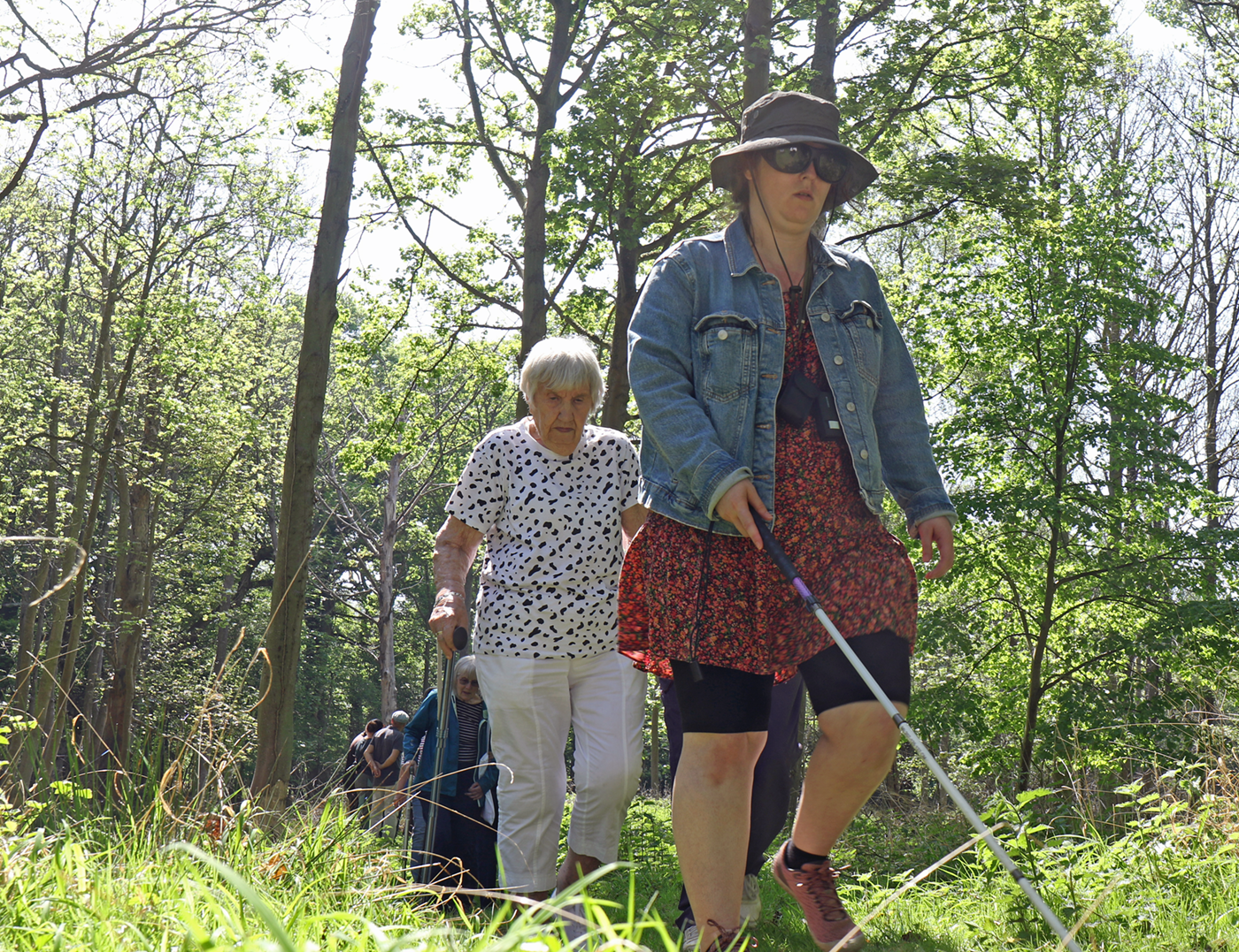
In addition to adding new routes to the rights of way network, guided tours have an important role on sites like ours where in some areas, creating permanent and safe new foot and cycleways isn’t possible.
Guided tours also let us act on our values and bring underserved groups into the world of rewilding and nature conservation. Access to nature is not a luxury; it’s an essential part of a healthy life.
Last week, we were delighted to host a group from local sight loss charity Vision Norfolk. Our adapted tour placed equal weight on sounds, scents and textures as well sights, which made for a brilliant shared experience where anyone could spot wildlife or be first to notice changes in the environment.
Guests walking through the beaver enclosure, image credit: Andy Newman
If you are a member of a charity or community group, and are interested in a guided tour of Wild Ken Hill, contact us!
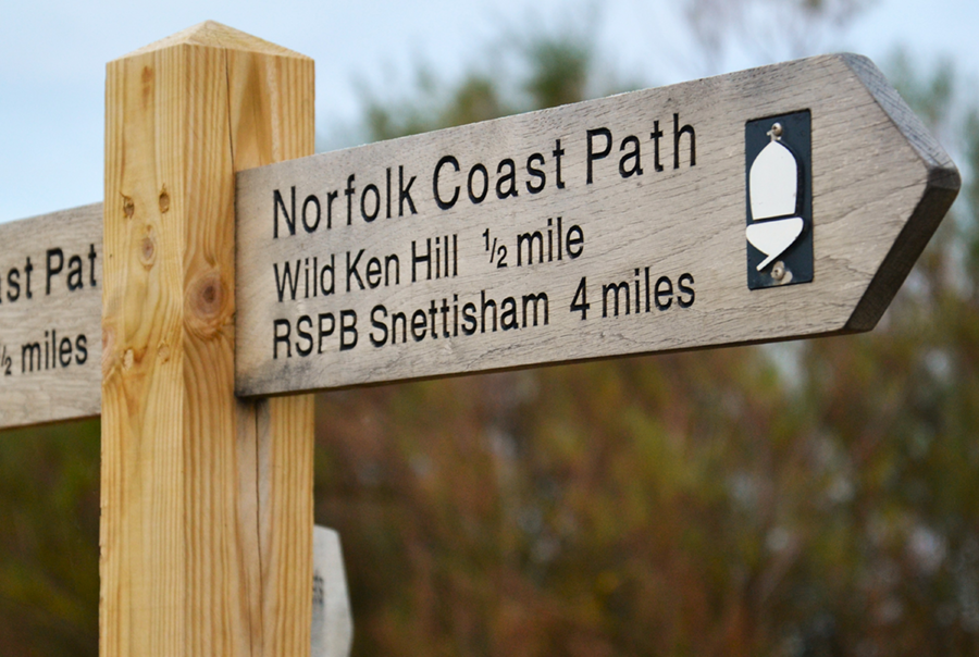
Visitors to the area might be wondering how they can experience the wildlife-rich landscape at Wild Ken Kill, in addition to booking a tour with our wonderful professional nature guides!
The map below shows the current network of public rights of way (black round dots) and permissive routes (gray square dots) that cross Wild Ken Hill:
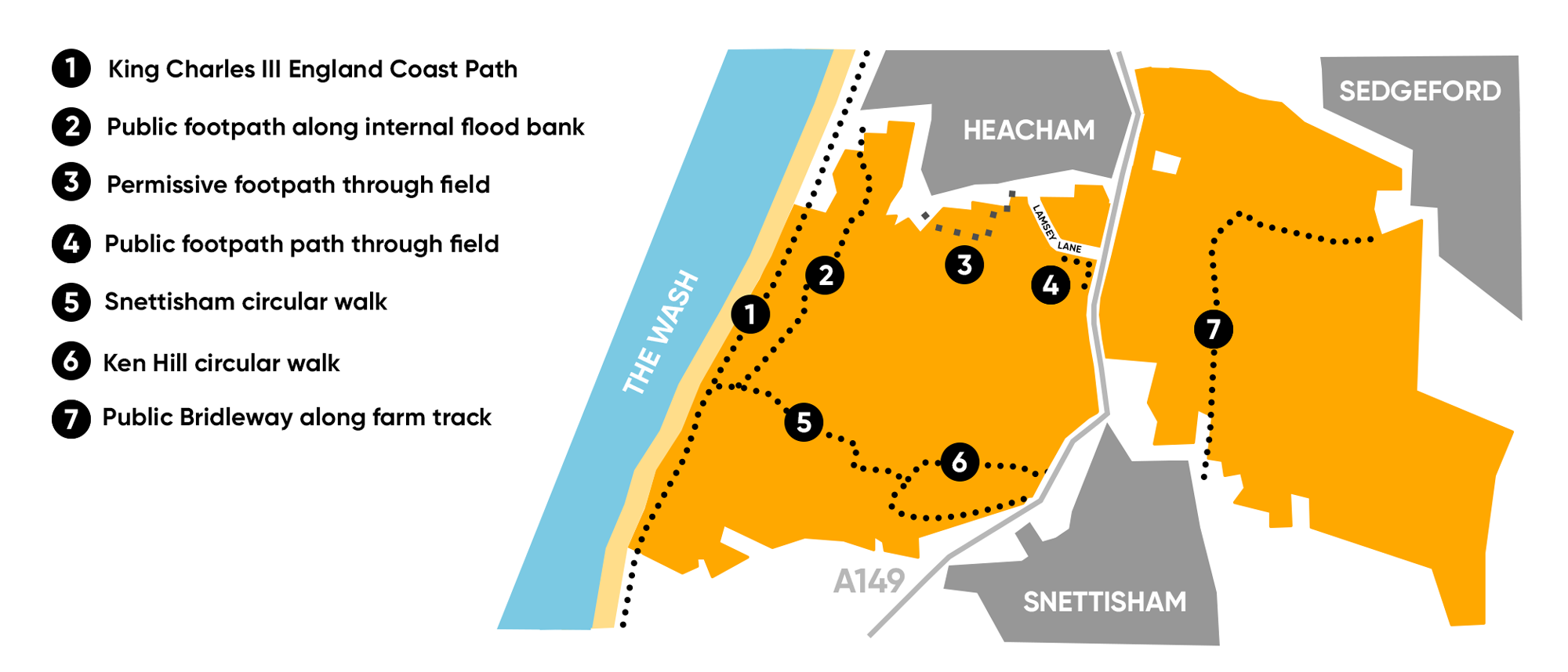
(Click map to enlarge)
To view these routes in detail, desktop users can access Ordnance Survey for free online via Bing Maps. The Ordnance Survey App for mobile is available for a monthly subscription.
Route 1 is part of the King Charles III England Coast Path, a long-term project by National Trails to connect the whole of England’s coast with one continuous walking route. The section that passes through Wild Ken Hill goes along the outer flood bank of The Wash and is a bird watcher’s paradise, with wading birds on one side and on the other, small birds hopping about in the reed beds of the coastal park as marsh harriers and other raptors circle overhead.
For a great view of the wildlife on our freshwater marsh, route 2 takes walkers along the inner flood bank, starting at Heacham South Beach Car Park and heading south till it connects to Route 5 – part of the beautiful Snettisham Circular Walk.
Our rewilding area does not have any public access, but the Snettisham Circular walk goes through it via a fenced route:
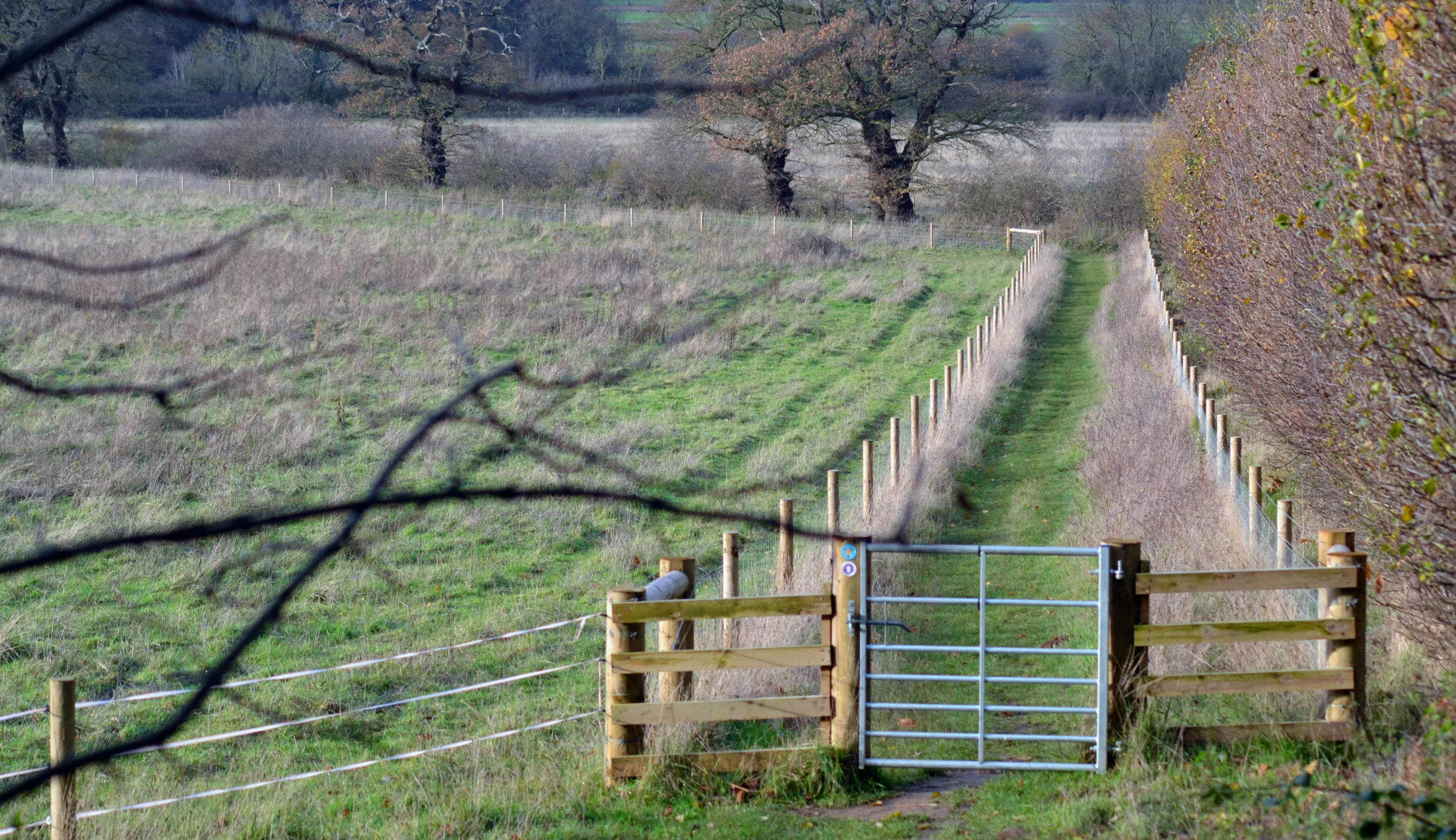
A view along part of the Snettisham Circular Walk which is fenced off from the rewilding area.
Walkers might catch sight of our grazing animals, particularly the Tamworth Pigs in the autumn as they hoover up delicious acorns in Ken Hill Woods. The Ken Hill circular walk (route 6) is short but stunning, with wide views across to the Wash.
We don’t have any plans to create public access to the rewilding area as it’s very important that our grazing herds – the ponies and cattle in particular – are protected from human interaction as much as possible so they can exhibit their natural behaviour. That’s why we run carefully controlled guided tours. The opportunity to witness the energy and beauty of undomesticated herds is rare in the UK, and income from tours helps with welfare costs like the ponies’ annual health check that featured in our February newsletter! (Subscribe to future editions here.)
Gravel cycling enthusiasts might be interested in Route 7, a public bridleway that connects the villages of Snettisham and Sedgeford. Here, walkers and cyclists might see an unusual amount of wildlife in this agricultural landscape, because this part of Wild Ken Hill is where our regenerative farming takes place.
Insects and birds thrive in cropland free from pesticides and fertilisers and interspersed with plenty of habitat – wide field margins and abundant hedgerows. In environment policy parlance, linear habitats like hedgerows called are ‘connectivity corridors’; important bridges between larger wildlife havens like scrubland and heath. Residents of Heacham may have noticed we’ve been planting new hedgerows close to the village this winter, which brings us on to…
As part of our commitment to improving access to nature for residents and visitors, balanced with respecting the ecological sanctitude of certain areas – we are trying to create new permissive routes and access areas.
In 2024, we created a new dog-walking area for Snettisham residents. The new hedgerows – however – are the first step in our plan to create a walking and wheeling route that links Heacham and Snettisham, letting local residents, seasonal residents and tourists enjoy a safe and scenic travel experience that is further away from the busy coast road.
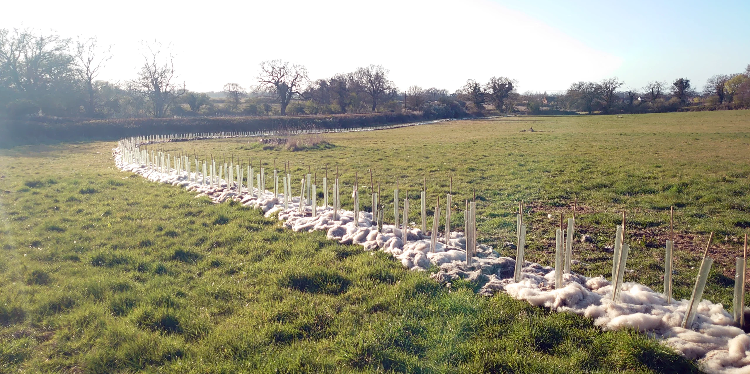
A newly-planted hedgerow showing young plants protected by tree guards and a layer of wool mulch to keep moisture in the soil.
Route 9 on the map below (blue round dots) is the first phase; linking the end of the pavement at Heacham with Route 4, an existing short footpath that will be resurfaced.
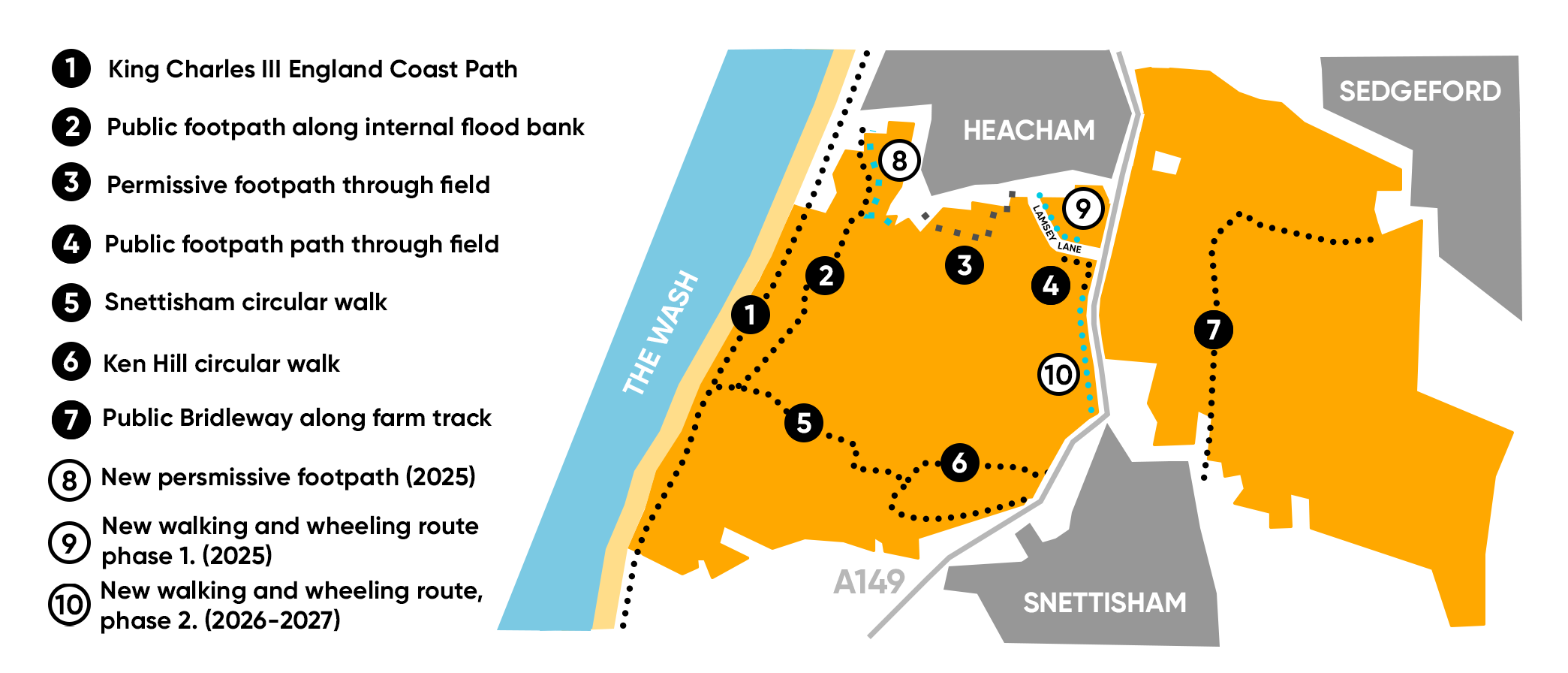
(Click map to enlarge)
Route 10 shows the second phase of the link-up, which we aim to complete in 2026-27.
A new permissive path, Route 8, is made possible thanks to our partnership with Environment Bank, who are carrying out work to create new habitat on a former arable field just south of Heacham. Along with new ponds, meadows and woodland, there will be a walking route just below the flood bank on its landward side. Perfect for winter walks sheltered from chilly north-westerly winds.
Thank you for reading!
We hope residents have found this preview useful, and visitors are inspired with ideas for how to explore and enjoy this wonderful corner of Norfolk that we are lucky to call home.